Black and white negative copy of a map of ancient walls in Limerick, taken for C. O'Carroll. Negative notes the initials T.J.C.
Shannon DevelopmentSecond edition black and white Ordnance Survey map sheet no. 82 of an area of county Tipperary on the county Waterford border on a scale of 6 inches to 1 statute mile. With extensive pencilled notes on the reverse, mainly relating to the location of tenants’ farms.
Looney, Timothy (Tim) (1914-1990), local historianSecond edition black and white Ordnance Survey map sheet no. 88 and 91A of an area in the junction of counties Cork, Limerick, Tipperary and Waterford on a scale of 6 inches to 1 statute mile. A section of the Suir River to the south of Ardfinnan has been outlined in pink.
Looney, Timothy (Tim) (1914-1990), local historianSecond edition black and white Ordnance Survey map sheet no. 74 of Aherlow and the Galty [Galtee] Mountains, county Tipperary on a scale of 6 inches to 1 statute mile. The words ‘Shooting Lease’ have been written in pencil on the reverse.
Looney, Timothy (Tim) (1914-1990), local historianMap of a walking tour of the Glen of Aherlow organized by Tim Looney, with a related timetable and information sheets on General Sir William Butler and General Liam Lynch. Also see P43/2/3/1, P43/3/2/2/10 and P43/3/2/5/2/1.
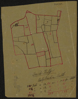
Looney, Timothy (Tim) (1914-1990), local historianMap on tracing paper of David Kelly’s holding on Ballybricken South [county Limerick].
Barry family of Sandville, Ballyneety, County Limerick and of Leamlara, County CorkBlack and white negative copy of a map for a Research Officer. Negative missing.
Shannon DevelopmentBlack and white negative copy of a map for Shannon Airport Free Development Company. Negative missing.
Shannon DevelopmentBlack and white negative of multiple aircraft on the Shannon Airport tarmac from control tower. Negative missing.
Shannon DevelopmentBlack and white negative of multiple aircraft on the Shannon Airport tarmac from the control tower. Negative missing.
Shannon Development