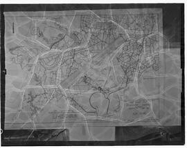
Map of that part of Dirrevillane held by Charlis [sic] Conry from John Hyde surveyed by Maurice Pigott. For a corresponding lease, see P43/1/3/2/2/2.
Looney, Timothy (Tim) (1914-1990), local historianBlack and white negative copy of the map of the Supersonic Transistor plan. Negative missing.
Shannon DevelopmentBlack and white negative of the line-map of Shannon Airport. Envelope notes the initials T.J.C.
Shannon DevelopmentBlack and white negative of the line-map of Shannon Airport. Envelope notes the initials T.J.C.
Shannon DevelopmentMap in two parts of the embankments and cuttings along the Great Southern and Western Railway between Maryborough and Rathnamanagh crossing the townlands of Moneyballyterrel, Little Borris and Borris Great. Includes a reference table of affected landholders and the amount of land required from each.
Coote Family, Barons CastlecooteFirst edition black and white Ordnance Survey map sheet no. 39 of part of Templebeg, county Tipperary and surrounding areas on a scale of 6 inches to 1 statute mile. Initialled and dated ‘1st Nov 1851’ in the bottom right hand corner.
Looney, Timothy (Tim) (1914-1990), local historianAs P43/2/4/1, with some sections coloured in, and with handwritten comments primarily of geological nature. Initialled and dated ‘1st Nov 1851’ in the bottom right hand corner.
Looney, Timothy (Tim) (1914-1990), local historianBlack and white Ordnance Survey map sheet no. XVIII/11 of Ballydavid, Dromina and Cooltegin in county Waterford on a scale of 25.344 inches to 1 statute mile.
Looney, Timothy (Tim) (1914-1990), local historianMap of Ireland showing the general election results for December 1918.
O'Mara family of Strand House, LimerickBlack and white poster of a map of Ireland showing the locations of chemical plants, uranium prospecting sites and toxic dumps. On the reverse is a related article entitled ‘Laying Ireland Waste’.
Dalby, Simon, Professor Emeritus
