Identity area
Reference code
Title
Date(s)
- 1900-1901 (Creation)
Level of description
Extent and medium
1 item
Context area
Name of creator
Biographical history
Charles James Coote was born on 19 August 1837 as the second of the five children Lieutenant-Colonel Charles James Coote of Mount Coote, county Limerick and Alice née Stuart. His elder brother having died in infancy, Charles succeeded to the Mount Coote estate in 1853, when his father was killed in action in the Second Anglo-Burmese War. Charles James Coote gained the rank of Captain in the 18th Royal Irish Regiment. He married Emily Pakenham in 1867 and died without issue on 11 March 1925.
Archival history
Immediate source of acquisition or transfer
Content and structure area
Scope and content
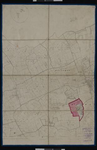
Part of Sheet 2 of the black and white first edition six-inch Ordnance Survey map for county Cork, on which the boundaries of the townland of Ballyhubbo have been marked out in a thick red line as part of the estate of Captain Charles James Coote. A thin red line marks the separation of the townland into two holdings. The holdings are individually numbered to correspond with the map reference numbers in the valuation book (P91/1). The map is supported by linen backing and bears two stamps of the General Valuation Office in Dublin with the dates 20 July 1900 and 4 April 1901, respectively.
Appraisal, destruction and scheduling
Accruals
System of arrangement
Conditions of access and use area
Conditions governing access
Conditions governing reproduction
Language of material
- English
Script of material
Language and script notes
Physical characteristics and technical requirements
Finding aids
Allied materials area
Existence and location of originals
Existence and location of copies
Available digitally on the University of Limerick Digital Library at https://doi.org/10.34966/uldl.dp3b-vj73.